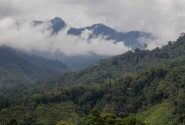


Landscape of natural production forest in concession area of PT. Sumalindo Lestari Jaya 2, in Long Bagun, West Kutai district, East Kalimantan, Indonesia.
BOGOR, Indonesia (8 August 2011)_ The Indonesian government is calling for public participation to help improve a map of primary forests and peatlands used to implement a two-year moratorium on new forest concessions to ensure maximum protection of these valuable resources.
Any individual, group or organization can download the maps in jpeg or shp formats and submit their inputs to the President’s Unit for Development Control and Monitoring (UKP4), the agency said in a public announcement (in Indonesian). The information will be verified and, once proven accurate, will be incorporated in the six-monthly update of the map.
The moratorium is one of the most important policies that came under President Susilo Bambang Yudhoyono’s commitment to reduce greenhouse gases emissions by 26% from business-as-usual levels on its own by 2020 and by 41% with outside assistance. The indicative map that was signed along with the moratorium has been criticized for inaccuracy and overlapping claims.
Information should be submitted in person, by mail or email and include a clear description and location of the land, either by using GPS, pictures or other maps, UKP4 said in the public statement.
UKP4 was also developing a system where the public could monitor and report deforestation by sending pictures and coordinates from their mobile phones, Kuntoro Mangkusubroto, head of the agency, said recently. The files would feed a server in President Yudhoyono’s office.
“In a democracy, the public is on the front line, not only in criticizing, but also in planning and monitoring,” Kuntoro said. UKP4 may launch the system as early as August, he said, without elaborating.
Indonesia is struggling to maintain the world’s third largest tropical forests amid pressures from logging, agriculture, mining, and population. About 1.18 million hectares of forests is lost every year, according to the Ministry of Forestry’s latest estimate. More than 60 percent of the country’s greenhouse gases emissions came from deforestation, land use change and peat fires.
The moratorium was part of an agreement with Norway to receive as much as US$1 billion if Indonesia could show verified emissions cut from the forestry sector. The decree was signed on May 20, 2011 and would be in effect in primary forests and peat lands for two years onwards, instead of retroactively from 1 January 2011 as initially planned.
We want you to share Forests News content, which is licensed under Creative Commons Attribution-NonCommercial-ShareAlike 4.0 International (CC BY-NC-SA 4.0). This means you are free to redistribute our material for non-commercial purposes. All we ask is that you give Forests News appropriate credit and link to the original Forests News content, indicate if changes were made, and distribute your contributions under the same Creative Commons license. You must notify Forests News if you repost, reprint or reuse our materials by contacting forestsnews@cifor-icraf.org.