Brazil’s deforestation tracking system – followed up with enforcement measures on the ground – is often cited as a key element of the dramatic reduction in Amazon deforestation over the past decade. But the system’s openness and transparency are at least as important as its technical and policy innovations, say experts.
Dalton de Morrison Valeriano has worked at Brazil’s equivalent of NASA – the National Institute for Space Research (INPE) – since the 1980s.
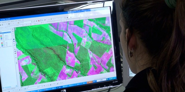
With a silver pony-tail and California-influenced drawl, he seems more former-rock-star than scientist – but he coordinates INPE’s Amazon deforestation monitoring program, which includes the satellite monitoring system PRODES (Program to Calculate Deforestation in the Amazon).
Since 1988, PRODES satellites have been recording annual deforestation in the Brazilian Amazon – although an earlier program began using satellites back in the 1970s.
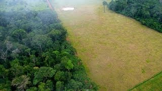
During the 1990s, INPE’s scientists sat watching at their computers as the destruction hit an all-time high – nearly 30,000 square kilometres were cleared in 1995. What made it all the more frustrating, Valeriano says, was that the data wasn’t publicly available.
“It was costing sleep at that time,” he said.
“It was very worrisome to see large deforestation happening almost at a daily pace, and to see that…the law enforcement apparatus was not in place completely. So we could see these things happening, but nothing could be done.”
“It wasn’t good for the institution to have the information and not to provide it freely available for anyone to check, to verify.”
This all changed in 2003, when Brazil’s new government decided to give the public full online access to PRODES satellite images, maps and statistics.
“From that point on, we became the provider of strategic information for deforestation control,” Valeriano says.
“We wanted to give everyone the means to check the map, to check its accuracy.”
“We got a very good response, even people who were sceptical about our capabilities could finally test it – and the product got much more respect by many users.”
Even more importantly, Valeriano says, publishing the data involved the public in Brazil’s fight against deforestation.
“It closed the loop,” he said. “In a way, it allows a society to check the progress of deforestation control. They know where it’s working, and [for] places where there’s evidence it’s not working, they can demand action.”
The consequences of transparency
This of course can pose a political risk for governments, says Sven Wunder, Principal Scientist with the Centre for International Forestry Research in Rio de Janeiro.
“You will actually know where and when deforestation is going on so you cannot hide behind the curtain of uncertainty, as you do in many countries in the region. So it’s a decision to create transparency around land-use that can have wide-reaching consequences,” he said.
“We can see in the Brazilian debate that people can pressure their local governments, they can pressure firms and corporate entities that are not acting as they should – it opens up a whole variety of influence that has not been there before.”
Valeriano says that back in 2003, there were concerns about the implications of such transparency. But, he says, it has only been good for Brazil.
“It has improved our reputation, not only INPE and the apparatus for monitoring and controlling, but the country itself, in terms of willingness to control deforestation. When we say we have reduced deforestation, it’s not something that we are just saying, we are showing it – and it’s pretty much accepted by everyone,” he said.
Deterring illegal deforestation
Reliable and independently verifiable annual deforestation data has been important to drive policy action and public responses – but PRODES shows where deforestation has already occurred, so it can’t be stopped in its tracks.
Brazilian society wants to see control over deforestation
So in 2004, INPE introduced a new satellite program. While PRODES measures deforestation in great detail, the new program, called DETER, detects it at a coarser resolution in near real-time, delivering data to Brazil’s environmental law-enforcement agency, IBAMA (Brazilian Institute of Environment and Natural Resources), every two weeks.
IBAMA can then have teams on the ground in the Amazon, stopping illegal deforestation and fining perpetrators in a matter of days (in theory – in practice it often takes longer.)
Here, too, transparency is a key principle, says George Ferreira, coordinator of environmental monitoring at IBAMA.
The names of people found to be deforesting illegally are entered into a public list online. Slaughterhouses can check the list to make sure the livestock they’re buying doesn’t come from a banned area; and banks refuse credit to those charged with illegal deforestation.
“I have the impression that a lot of people in Brazil are not ashamed of committing environmental crimes, but if you go for their pockets – if they can’t sell their products or get a loan at the bank – it will discourage them,” Ferreira said.
The system doesn’t work perfectly – especially during the rainy season, when heavy cloud cover prevents INPE’s satellites from seeing what is happening on the ground.
“Clouds actually force us to work within certain windows,” Valeriano says.
“So we can work very well from May through to September or October, but we are very limited [during] the other months.”
INPE is now trialling radar technology as a way to see beneath the clouds – but Valeriano says more work is needed.
”It is good, but it misses some deforestation, so it’s not adequate for a thorough map – but for detection purposes it’s the best option for the rainy season,” he said.
But new technologies are rapidly emerging. In fact, a recent CIFOR study focusing on the Juma Sustainable Development Reserve in Amazonas found that at small spatial scales the PRODES system significantly under-detected deforestation there compared with new (more labour-intensive) methods.
Sharing the technology
As the organisations develop new technical solutions, as part of the ethos of transparency, both IBAMA and INPE are also sharing knowledge and technology with other countries.
IBAMA develops its monitoring tools using only free, open-source software, Ferreira says. It’s in the final stages of developing a software package for online mapping, which will be made available on the internet for free download.
Meanwhile, INPE holds workshops in Africa, Asia and in other Amazonian countries, sharing software and training people how to set up their own deforestation monitoring programs.
“Of course we don’t want to do service for other countries; that’s not the purpose of the institution. What we can do is build capacity – and that we are already doing all the way from Papua New Guinea to Ecuador,” Valeriano says.
How well those systems flourish elsewhere will depend on political willingness to embrace transparency. But could political change in Brazil itself threaten the deforestation monitoring program?
“That’s the only thing we don’t control, the future,” says Valeriano.
“But if anyone wants to say shut down this program or turn it to a different direction, it’s going to have a huge resistance, because of the public awareness that we’ve built up.”
“Brazilian society wants to see control over deforestation.”
For more information on the issues discussed in this article, please contact Sven Wunder at s.wunder@cgiar.org
We want you to share Forests News content, which is licensed under Creative Commons Attribution-NonCommercial-ShareAlike 4.0 International (CC BY-NC-SA 4.0). This means you are free to redistribute our material for non-commercial purposes. All we ask is that you give Forests News appropriate credit and link to the original Forests News content, indicate if changes were made, and distribute your contributions under the same Creative Commons license. You must notify Forests News if you repost, reprint or reuse our materials by contacting forestsnews@cifor-icraf.org.


