Underneath the swamp forests and palm trees of the Congo Basin lies a hidden wealth: more than 145,000 square kilometers of carbon-rich peat.
The peatlands of the Congo Basin have formed over thousands of years, and are estimated to contain about 30 billion tons of carbon – a similar amount to the carbon stored in all the forests of the Republic of Congo and Democratic Republic of Congo combined.
This remarkable discovery increases global estimates of tropical peat carbon stocks by 36 percent, and makes the Congo Basin the most extensive peatland complex in the tropics.
Tropical regions have long been overlooked in the study of global peatlands, due to an assumption about peat forming mainly in cold climates. But new research finds there may be up to three times more peat in the tropics than previously estimated, with implications for sustainable management and action on climate change.
“At first, there was a belief that heat would work against peat accumulation in the tropics,” says Rosa Maria Roman-Cuesta, a researcher with the Center for International Forestry Research (CIFOR).
“We now know that waterlogging prevents heat from affecting decomposition. Therefore, while in northern boreal peats it is temperature that mainly controls accumulation of organic matter, in the tropics it’s water.”
As our understanding of tropical peat develops, new predictive methodologies combined with ground fieldwork are confirming the existence of vast peat deposits in the tropics, and are helping put numbers to their area, volume and carbon stocks.
“There is much more peat in the tropics than we previously thought, and we also have a lot more carbon stocks in peatlands in the tropics than we previously thought,” Roman-Cuesta says.
DIGGING DEEP
The massive carbon stocks of the Congo Basin and other regions have until now gone unnoticed because tropical peatlands tend to be remote, densely vegetated, and not very well understood. While researchers have long claimed that the ecological conditions for peat formation exist in the tropics, field data has yet to confirm this in many areas.
Simon Lewis, a professor at Leeds University and University College London in the U.K., was part of the team that confirmed the existence of peat wealth in the Congo Basin. He presented the findings at a side event led by CIFOR and partners at the recent UNFCCC Bonn Climate Change Conference in Germany from May 8-18.
“No satellite can detect peat, only features that are associated with it,” Lewis says.
While the view from a satellite can reveal wetland areas, he says, it can’t “see” peat hidden under forest cover, and continuing deep into the ground. Knowledge of the process of peat formation in the tropics is also still in the beginning stages, making it hard to know where to look, and to estimate how deep the peat may run.
The only way to really verify the presence and depth of peat, Lewis says, is to actually go to a site and dig up the evidence.
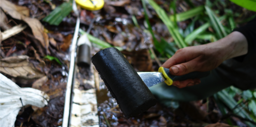
So that’s what his team did. With the help and knowledge of local guides, the researchers rowed and trekked into remote areas, sometimes up to two weeks’ walk away from the nearest river access, to extract soil samples to take back to the lab for testing. Rich, black soil found to be composed of 65 percent carbon or more, reaching more than 30 centimeters deep into the ground, met the team’s definition of peat.
So how did the team know where to look?
First, they identified conditions under which tropical peat is formed. Year-round water-logging in swamp forests with nutrient-poor water appeared to do the trick, impeding microbia from breaking down plant matter and leaving behind layers of peat.
From there, the team identified three types of vegetation under which peat tended to occur. Using satellite maps to identify areas covered by these types of vegetation, they set out on an expedition to test their hypothesis.
The next step was to scale up the findings by mapping vegetation based on ground research, and running the data, while holding some data back to test the quality of the new map. The results showed an astonishing 30 billion tons of carbon in the area that had previously gone unnoticed.
“In other words, as much carbon as the second-largest area of tropical forest in the world, but in a much, much smaller area,” Lewis says.
VIEW FROM ABOVE, VIEW FROM BELOW
Research is ongoing into other methodologies for predicting and confirming the existence of peat in the tropics, including by finding new uses for satellites as the technology improves.
At the side event in Bonn, Roman-Cuesta presented on a new expert system model that offers hypotheses on the biological processes behind peat formation, as a way to work with satellite data to produce peat maps.
“Countries cannot afford to run field campaigns blindly. It is just too expensive and not efficient. Like it or not, satellite data to map wetlands and peatlands are a fundamental requirement for future fieldwork on peat research,” she says.
Satellites have already been detecting peat for decades through fire, methane emissions, and other indirect peat indicators, such as vegetation types or soil moisture levels, Roman-Cuesta says.
“Satellites can offer far more than optical data: precipitation, topography, temperature or emissions are common products of the satellite family,” she adds.
Nonetheless, ground-truthing fieldwork is still needed to confirm the presence of peat on, or in, the ground, making collaboration between top-down and bottom-up stakeholders an essential part of managing peatlands around the world.
UNDER THREAT
The latest findings from the Congo Basin have enormous implications for conservation and climate change mitigation and adaptation. As countries move to incorporate peatlands in their Nationally Determined Contributions (NDCs) under the Paris Agreement, being able to calculate carbon wealth is increasingly crucial.
The carbon-rich peat found by Lewis and colleagues is estimated to have accumulated in the Congo Basin at the crawling rate of about 0.2 millimeters a year over thousands of years. It has been building up in the ground about as long as humans have been in the area, dating back to the beginning of the Holocene epoch.
“That’s why it’s important to keep it there and not allow it to go back out into the atmosphere,” Lewis says.
Throughout the tropics, peatlands are under the pressures of industry, agriculture, urbanization, and increased frequency of fire and drought as a result of climate change and other factors. Disturbing these ecosystems will lead to a massive release of greenhouse gases into the atmosphere, while conserving them will keep their carbon stocks locked in the ground.
Further research is also needed on the characteristics and conditions of tropical peat, using data from above and from below. Increased knowledge can assist climate change adaptation efforts, by locating areas in need of re-wetting and restoration.
And yet despite the significance of the Congo Basin’s peatlands, around 20 percent of the area discovered by the research team has already been marked for logging, with allocations for permits granted.
“Those pressures are on the horizon,” Lewis says.
We want you to share Forests News content, which is licensed under Creative Commons Attribution-NonCommercial-ShareAlike 4.0 International (CC BY-NC-SA 4.0). This means you are free to redistribute our material for non-commercial purposes. All we ask is that you give Forests News appropriate credit and link to the original Forests News content, indicate if changes were made, and distribute your contributions under the same Creative Commons license. You must notify Forests News if you repost, reprint or reuse our materials by contacting forestsnews@cifor-icraf.org.


