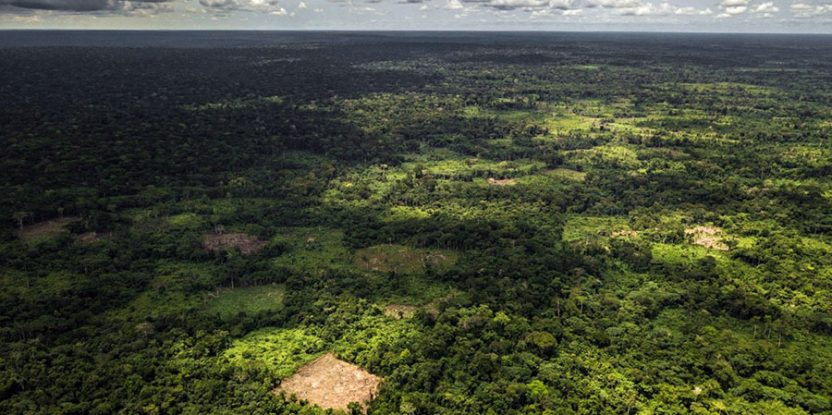
At least 27% of undisturbed rainforests in the Congo Basin present in 2020 will disappear by 2050 if the rate of deforestation and forest degradation continues unperturbed, a new report has shown.
There was an estimated 200 million hectares of evergreen and semi-deciduous forests in Central Africa, including Angola and Uganda, in January 2020 – with 184.7 million hectares showing no signs of disturbance, according to a report on the state of Congo Basin forests produced by the Observatory for Central Africa Forests (OFAC). Unfortunately, the rate of loss of intact forests has since then accelerated, with no fewer than 18 million hectares of forests disappearing so far.
The French version of the report was launched during the 19th Meeting of the Parties of the Congo Basin Forest Partnership, and the English version was released last week.
Authors of the first chapter of the report led by Juliette Dalimier indicate that there has been a significant increase in the annual rate of disturbance of the rainforest between 2015 and 2020, which topped 1.79 million hectare per year. In the decade preceding 2015, the yearly toll stood at 1.36 million hectares. The annual rate of disturbances has increased in all Central African countries since 2009.
The Democratic Republic of the Congo (DRC) stands as the first in Africa and the second in the tropical world with the largest remaining area of undisturbed tropical rainforest measuring 105.8 million hectares. Cameroon, Gabon and Congo show similar areas of intact forests ranging between 19.8 million hectares and 23.4 million hectares.
“To develop the report, the forest was mapped in terms of floristics, physiognomy and carbon stock. Management-volume inventory data collected by 105 forest concessions across Central Africa, excluding areas of high altitude and excess soil water, for the floristic mapping was also factored. Some 6 million trees over 30 cm in diameter and covering approximately 90,000 hectares were analysed, which enabled the researchers to categorize three floristic gradients based on climate, seasonality and maximum temperatures as well as human activity,” Dalimier explained.
Aiming for detailed results, the researchers also used a recent technique of mapping of forest types on a physiognomic basis, which gave them spatially detailed information on 20 m spatial resolution and semantics never before achieved for such geographical coverage. This was thanks to Sentinel-2 satellite data acquired in 2020 and a new method of image correction that involves filling in areas covered by cloud with observations from 2018–2019 obtained from radar-like Sentinel-1 satellite insensitive to cloud disturbances. This approach enables the production of a coherent annual composite.
However, because of the paucity of field observations and difficulties in extrapolating carbon stocks through remote sensing, the researchers were unable to determine the spatial distribution of forest carbon stocks across Central Africa.
Thanks to research that classified the area under study into undisturbed forest, degraded forest and non-forest at subnational level, the researchers were able to find out that administrative units with less undisturbed forest were more fragile because they usually have a higher proportion of degraded forest. It emerged that most of the wooded areas converted to tree plantations between 1990 and 2020 in Africa are located in DRC (80,000 ha), Cameroon (70,000 ha) and Gabon (40,000 ha).

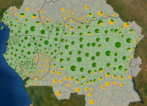
Proportion of intact forest (dark green), degraded forests (light green) and non-forest by administrative unit according to 2019 Tropical Moist Forest data. In the figure, areas deforested before 2019 are classified as non-forest. Source: OFAC
Based on the study, the researchers were also able to determine that, over the entire Congo Basin, 5% of protected areas are overlapped by mining titles, 65% of which are occupied by intact or degraded forests. According to the report, DRC and Central African Republic experience the most significant forest degradation and deforestation related to the mining sector. Besides artisanal mining, it should be noted that 11.6% of Congolese territory (DRC) is covered by mining titles, 35% of which is forest.
The researchers also found out that deforestation needed to set up the infrastructure required for large-scale mining operations leads to both direct (biodiversity loss) and indirect (pollution of the aquatic environment) effects. At the same time, the influx of people aiming to benefit from the economic assets of mining leads to the development of poaching and subsistence agriculture in or near adjacent forests.
PROTECTED AREAS PARADOX
Responding to the need to curb pressure on forests, preserve ecosystems rich in fauna and flora, as well as provide benefits to forest-adjacent communities, governments in Congo Basin have created many protected areas over the past two decades. Unfortunately, weak technical and human resources, political instability, lack of funding and existing conflicts in many countries of the sub-region have thwarted such efforts. This has resulted in making the proper management of these protected areas difficult, although the researchers believe land allocation policies on protected areas are a valuable tool in the fight against deforestation and forest degradation.
“Protected areas, forest concessions and community forests make it possible to considerably reduce forest losses and involve local populations in the conservation of forests while ensuring their subsistence,” said Pierre Ploton of the French Agricultural Research Centre for International Development (CIRAD), another contributor to the report.
Being only second to the Amazon in terms of dense humid forest, Congo Basin forests stand out as exceptional reservoir of carbon – holding about 40 gigatonnes of carbon – as well as biodiversity for the countries of Central Africa and for the planet. The urgency to preserve these cannot be overemphasized, as these forests hold the means of subsistence for some 60 million people and help feed an additional 40 million in nearby urban centres.
“Central Africa is a priority region for biodiversity conservation because of its exceptional heritage and high level of endemism. Its ecosystems have the value of a common good, both for current generations, the millions of people who benefit from the natural resources they provide, and for future generations. As with the rest of the planet, the biodiversity of the sub-region is threatened by many factors, and its fate must therefore be seen as a joint responsibility of the countries of Central Africa and the international community’, said Richard Atyi, CIFOR-ICRAF’s regional Convener for Central Africa.
The research has been supported by the European Commission through the RIOFAC project.
We want you to share Forests News content, which is licensed under Creative Commons Attribution-NonCommercial-ShareAlike 4.0 International (CC BY-NC-SA 4.0). This means you are free to redistribute our material for non-commercial purposes. All we ask is that you give Forests News appropriate credit and link to the original Forests News content, indicate if changes were made, and distribute your contributions under the same Creative Commons license. You must notify Forests News if you repost, reprint or reuse our materials by contacting forestsnews@cifor-icraf.org.
