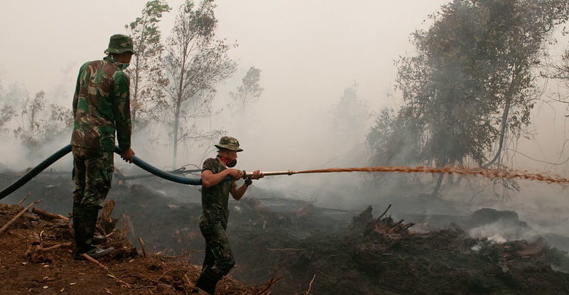
Indonesia’s peatland fires are better explained by a newly developed approach that considers climate-change impacts and helps predict hotspots of carbon emissions and air pollution from the burning of peat, according to scientists.
A rain-related index used by the Japan Meteorological Agency has shown a stronger correlation with active peatland fires in Indonesia than the conventional benchmark based on El Niño-Southern Oscillation (ENSO) climate patterns over the past two decades.
The finding, which focuses on groundwater levels as a key determinant of peat fires, will make it easier to respond to fire forecasts associated with extreme weather and climate change, according to a recent study funded by the Ministry of Agriculture, Forestry and Fisheries of Japan in collaboration with the Center for International Forestry Research (CIFOR) and Indonesia’s University of Palangka Raya (UPR).
Peatland fires are a major contributor to greenhouse gas emissions, fine particulate matter and aerosols, exacerbating climate change and endangering human health. They can smolder for months and are linked to land management as well as other activity near human settlements.
Farmers have traditionally used fire as a cheap way to clear land for agriculture in Indonesia, which has one of the world’s highest rates of deforestation and forest degradation.
In 2016, the Indonesian government established the Peatland Restoration Agency (BRG) with the aim of restoring 2 million hectares of degraded peatlands.
Indonesia’s worst blazes in recent decades, starting with the Great Fire of Borneo (1982‒1983), have been associated with strong ENSO episodes. Sea surface temperatures and winds in the equatorial Pacific Ocean fluctuate during these cycles and can affect global weather. They also influence tropical rainfall and can create the conditions for wildfires and other extreme events.
In 2019, peatland fires occurred without this ENSO correlation, prompting scientists to seek a new approach that considers the impact of recent climate change on fires in Indonesia.
“Our analysis of Indonesian peat fires in 2019 showed that they are difficult to extinguish even with periods of heavy rain – it depends on the groundwater level,” said Hiroshi Hayasaka, a researcher at Hokkaido University’s Arctic Research Center in Japan and the study’s lead author. “In years when the rainfall is low, peat fires become very active.”
The three authors focused on tropical swamp forest areas near Palangka Raya, the capital of Central Kalimantan province, where a former Mega Rice Project constructed a 4,000-kilometer irrigation canal that drained the surrounding peatlands. As a result, greater volumes of combustible dry peat (low-grade coal) were exposed, causing recurrent fires in the area.
The Japanese rain-related index is known as OLR-MC (Outgoing Longwave Radiation – Maritime Continent) and measures the transport of heat and moisture in the atmosphere over Indonesia (from Kalimantan to West Papua).
It was introduced to analyze the top six peatland fires in Kalimantan from 2002 to 2018, showing they occurred in three stages: surface fire, shallow peatland fire and deep peatland fire.
The scientists then proposed a prediction model for groundwater level, which is important for knowing the dry state of peat and is estimated from daily rainfall. Analysis showed that the groundwater depth for each fire stage ranged from about 300 millimeters to 500 millimeters.
Peatland fires during the three stages depend on these values: When the groundwater level falls, the moisture content of the peat declines and it can be burned more easily.
“The proposed model is very simple – all you need is daily rainfall estimates,” Hayasaka said. “In the case of Indonesia, it is essential to measure the groundwater level of each peatland and take steps to ensure that it doesn’t fall below 300 millimeters.”
Active peatland fires in Indonesia — including those in 2019 when the El Niño conditions were neutral — are therefore explained by the groundwater level. In particular, it is important to predict the occurrence of deep peatland fires, which the proposed evaluation model was able to do, according to Aswin Usup from UPR, who supervised the study.
Satellite technology underpins this new approach. Rainfall data is provided by the Japan Aerospace Exploration Agency, the Japan Meteorological Agency and the U.S. National Oceanic and Atmospheric Administration, while the Terra and Aqua satellites operated by NASA deliver data from an imaging instrument that detects tropical forest and peatland fires.
“This rainfall-based evaluation approach fills a research need that links peatland fire prediction and groundwater levels,” says Daisuke Naito, a CIFOR scientist and co-author of the study.
“The use of an OLR index will be very useful for analyzing future tropical fires related to both El Niño and climate change,” Hayasaka adds.
We want you to share Forests News content, which is licensed under Creative Commons Attribution-NonCommercial-ShareAlike 4.0 International (CC BY-NC-SA 4.0). This means you are free to redistribute our material for non-commercial purposes. All we ask is that you give Forests News appropriate credit and link to the original Forests News content, indicate if changes were made, and distribute your contributions under the same Creative Commons license. You must notify Forests News if you repost, reprint or reuse our materials by contacting forestsnews@cifor-icraf.org.