The ongoing Ebola virus outbreak in West Africa has claimed more than 11,000 lives since March 2014. Yet we still know very little about the conditions in which the virus thrives and how it spreads to humans.
Some answers may be found in a groundbreaking new study that borrows techniques from biology and geography to map out hotspots where the virus may be lurking.
A research team led by scientists John Fa and Robert Nasi from the Center for International Forestry Research (CIFOR) together with Jesús Olivero and colleagues from the University of Málaga, including US virologist Jean Paul Gonzalez and Zoological Society of London wildlife epidemiologist Andrew Cunningham, took a biogeographical approach to mapping favorable conditions for the Ebola virus, both in terms of environment and the presence of animals as potential hosts.
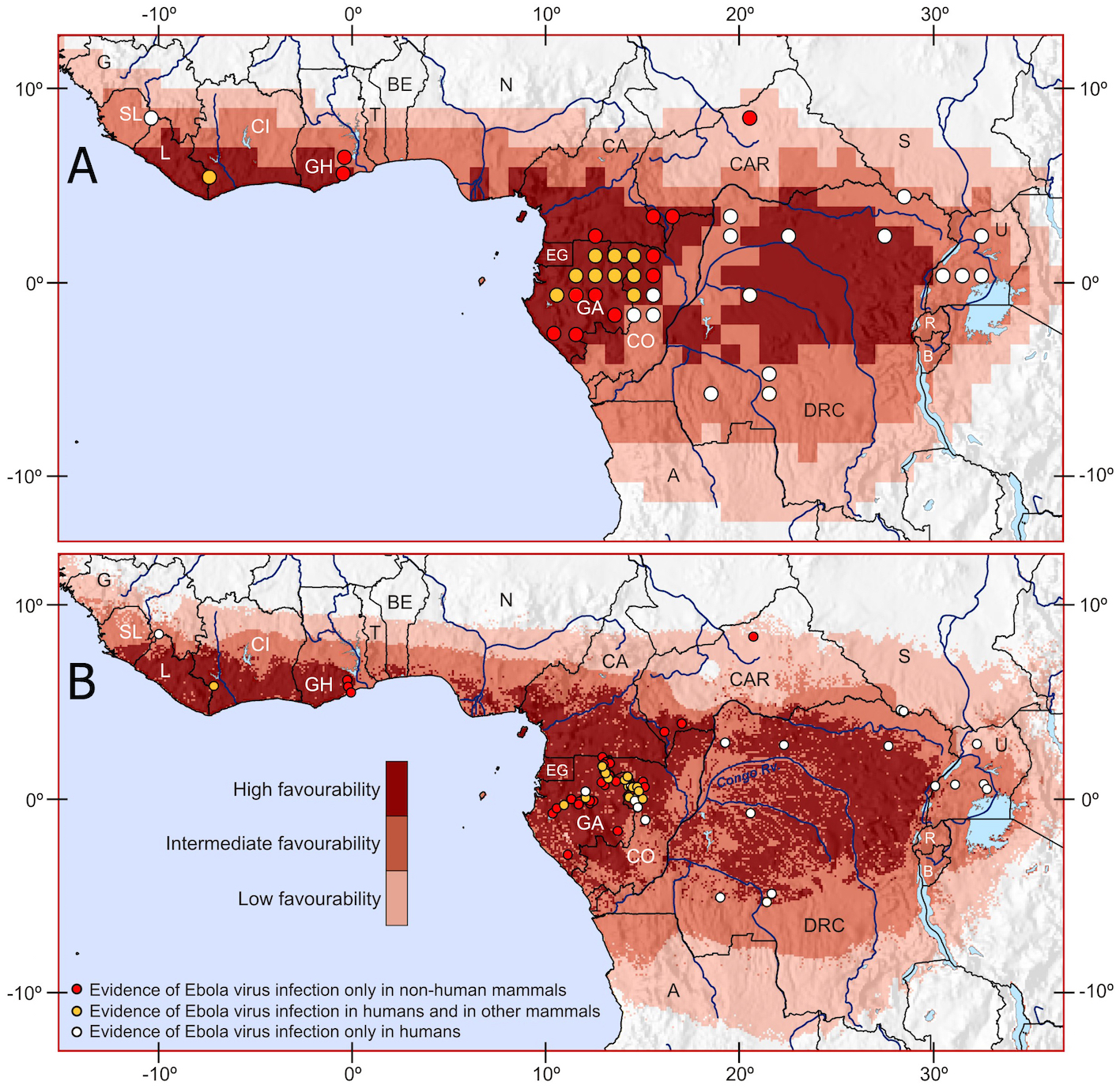
The resulting map from the study suggests that favorable conditions for Ebola are more widespread than suspected, stretching across 17 countries throughout West and Central Africa, and as far as the East African Lakes Region.
It also finds a strong link between Ebola and tropical rainforests, and suggests a list of more than 60 wild animals that require further investigation as potential carriers of the disease.
The findings could help save lives.
“This information is essential for the development of early warning systems aiming to optimize the efficacy of prevention measures,” said Olivero.
TRACKING A VIRUS
Olivero and his team are among the world’s leading researchers in the area of “biogeography”, or the science of mapping biological patterns across time and space.
Biogeographic mapping allows scientists to not only analyze the distribution of an organism, but also to predict where that organism may be found based on the existence of favorable environmental conditions.
As a virus, Ebola is in fact an organism. Recognizing this, Olivero and colleagues took biogeographic mapping techniques that are normally used for animals, and applied them to the case of a virus.
Geographical information system (GIS) software was used to map the distribution of favorable environments for Ebola to occur in, as well as the spread of mammals known to have died from, or been infected by, the virus.
“Our findings provide new information about how the Ebola virus is distributed in the wild, before it is transmitted from humans to humans,” said Olivero.
Preconceptions that only bats are to blame for carrying the virus were disregarded, with analysis extended to 64 species including rodents, primates, hoofed animals, a civet and a shrew as potential reservoirs of Ebola virus.
The resulting map found a wider than expected spread of Ebola both among mammal populations and across the African continent.
We have to have very clear and realistic ways of trying to stop the transmission from infected animals to people
THE HUMAN CONNECTION
So what do the findings mean for humans? This is where the work of CIFOR scientists John Fa and Robert Nasi comes in. Fa and Nasi are experts on bushmeat, or wild animals harvested for food and non-food purposes.
One of the major causes of transmission for Ebola is the hunting, butchering and consumption of wild animals. But putting a blanket ban on bushmeat is not a viable measure – and neither is hunting all species suspected as carriers.
“We don’t want people to be alarmed that there are so many different species, and start killing as many as possible,” said Fa.
“We have to have very clear and realistic ways of trying to stop the transmission from infected animals to people without necessarily stopping people from doing what they’ve done, which is essentially hunting for food.”
Fa said that working with at-risk hunters and communities will be critical for stopping the spillover of infection from animals to humans.
Further research into the communities of animals identified in the study, and how their habitats are affected by human activities such as deforestation and urbanization, is also needed.
In the meantime, it’s hoped that the new method of mapping will help identify hotspots for Ebola and prevent contagion.
We want you to share Forests News content, which is licensed under Creative Commons Attribution-NonCommercial-ShareAlike 4.0 International (CC BY-NC-SA 4.0). This means you are free to redistribute our material for non-commercial purposes. All we ask is that you give Forests News appropriate credit and link to the original Forests News content, indicate if changes were made, and distribute your contributions under the same Creative Commons license. You must notify Forests News if you repost, reprint or reuse our materials by contacting forestsnews@cifor-icraf.org.

