When I prepare for field research, I brace myself for rough terrain, unpredictable weather and endless logistical challenges. Yet nothing could have prepared me for being in the path of a cyclone—or for the profound reliance I would place on the mangroves around me for protection.
In October 2024, I traveled with a team of researchers from the Center for International Forestry Research and World Agroforestry (CIFOR-ICRAF), the US Forestry Service (USFS) and Odisha state forest department staff to Bhitarkanika, the second—largest deltaic mangrove forest in India after the Sundarbans. Located at the confluence of the Brahmani and Baitarani rivers in Odisha State, this extraordinary landscape encompasses the Bhitarkanika Wildlife Sanctuary, National Park and Gahirmatha (Marine) Wildlife Sanctuary.
Bhitarkanika is a critical habitat for saltwater crocodiles (Crocodylus porosus) and possibly the world’s largest mass nesting ground for the endangered olive ridley sea turtle (Lepidochelys olivacea). Recognised as a Ramsar Site in 2002, it is not only a biodiversity hotspot but also a vital natural shield, safeguarding coastal areas from storms and erosion while offering essential ecological benefits.
The work in Bhirtarkanika is part of a broader initiative to monitor mangrove health sites across India. This includes sites in the Sundarbans Biosphere Reserve in West Bengal, the Andaman and Nicobar Islands and Coringa Wildlife Sanctuary in Andhra Pradesh. The nationwide project, a joint effort between CIFOR-ICRAF, USFS and state governments, applies a systematic methodology to assess the resilience of India’s mangrove ecosystems.

The team installs the rSET. Photo by Mr. Sudip Debnath / Vidyasagar University.
In Bhitarkanika, as part of the project, our team’s mission was to install rod surface elevation tables (rSETs) and automated salinity and water depth loggers. These devices can track subtle yet significant changes in mangrove health and resilience over time, including shifts in soil elevation and salinity levels. This long-term monitoring is crucial for understanding how mangroves respond to environmental stressors, particularly those driven by climate change. Such data can then support the development of more effective conservation and management strategies.
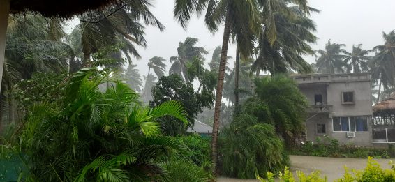
However, just as we began our fieldwork, we received news that Cyclone Dana—a category one tropical storm— was approaching. We paused our work to ensure everyone’s safety and sought shelter in a small homestay in Dangamala, Rajnagar, surrounded by thick mangrove forests.
On 24 October, as the cyclone approached landfall and winds intensified, we gained a new appreciation for the strength and resilience of the mangrove ‘walls’ surrounding and protecting us. As mangrove scientists, we already knew that mangroves act as natural buffers, absorbing and dissipating the force of winds and waves and protecting nearby communities by reducing the cyclone’s energy.
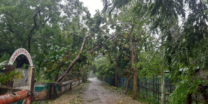
Yet it was one thing to read about such protective benefits and quite another to experience it firsthand was entirely different. From within the shelter of the forest, we could hear the storm’s ferocity—a stark reminder of the devastation such storms can bring to unprotected coastlines. But around us, the mangroves absorbed much of the impact, remaining resilient in the face of the cyclone.

Cyclone Dana crossing. Photo by Utchimahali Mariappan / CIFOR-ICRAF
This experience gave a new meaning and purpose to our work on the ground. By installing rSETs and data loggers, we can now document and quantify the protective services of mangroves, such as changes in soil elevation, water levels, and storm impact. Knowing that our data will capture the crucial role of mangroves in safeguarding coastlines makes our efforts feel particularly worthwhile.
Once the cyclone had passed, we returned to our installations, deeply grateful for the protection Bhitarkanika’s mangroves had afforded us. Our data loggers are now actively recording salinity, temperature and water levels, providing essential insights into the forest’s resilience against rising sea levels and storms.
Cyclones are very common in the Bay of Bengal and often severely impact both the Sundarban Biosphere Reserve and Bhitarkanika National Park. Mangroves continue to thrive through these extreme weather events. Still, it is unclear how long their resilience may last in the face of multiplying and intensifying threats such as sea level rise, environmental stress, and more frequent extreme weather events.
As such, “a long-term robust dataset and scenario-based species-specific models are necessary to understand impacts of global climate change on mangroves,” said Sahadev Sharma, a USFS scientist and a fieldwork team member. “Conservation and management of existing mangroves are critical following science-based restoration and rehabilitation.”
“A deeper understanding of these natural systems’ response to complex anthropogenic and natural pressures is crucial for better decision-making,” added Rupesh Bhomia, the CIFOR-ICRAF scientist responsible for establishing long-term mangrove monitoring sites nationwide.
This fieldwork was a critical juncture in my career, reaffirming why I chose this field of research. Mangroves are far more than just coastal vegetation: they are natural shields against climate extremes, protectors of biodiversity, and invaluable resources for surrounding communities. Working in Bhitarkanika during Cyclone Dana deepened my appreciation for these ecosystems and the countless lives they protect—human and otherwise.
We want you to share Forests News content, which is licensed under Creative Commons Attribution-NonCommercial-ShareAlike 4.0 International (CC BY-NC-SA 4.0). This means you are free to redistribute our material for non-commercial purposes. All we ask is that you give Forests News appropriate credit and link to the original Forests News content, indicate if changes were made, and distribute your contributions under the same Creative Commons license. You must notify Forests News if you repost, reprint or reuse our materials by contacting forestsnews@cifor-icraf.org.
