Analyzing the range of variables involved in land management and land restoration management is a daunting task for even the most experienced of scientists, particularly in dryland areas.
More than 2 billion people live in these complex ecosystems, which cover 40 percent of the world’s surface. Scientists with World Agroforestry (ICRAF) are working together with the Makueni County government in Kenya to determine how best to mitigate the impact of unpredictable rainfall patterns and severe land degradation – exacerbated by climate change – on human livelihoods, plants and animals.
To do so, they have co-designed a new resource hub for the county, an open-access website that will store data and maps on key progress indicators for restoration, including baseline assessments of social and ecological variables. Set to launch in the second half of the year, the new “decision dashboard” will make interactive information and data readily available in visual form in a single location.
It can be customized to suit any context or user and — based on user feedback and design requests — will include quantitative and qualitative information, graphs, charts, photographs, videos, documents and maps. It will have the capacity to illustrate trends and analyze various threads of information to inform decision-making.
Six decision dashboards have already been developed by ICRAF, and are available online via the ICRAF Geoscience Landscape Portal.
Through effective land restoration interventions and the prevention of farming practices that contribute to land degradation, scientists say they can enhance biodiversity and increase the resilience of communities to the effects of climate change.
Strong collaboration and robust data are essential components of successful prioritization, planning and implementation of land restoration activities and policy development.
The CGIAR Research Program on Water, Land and Ecosystems (WLE), which connects partners to deliver agricultural solutions that enhance natural resources and livelihoods, played a key role in the development of the hub through funding.
It is co-designed with key stakeholders from Kenya’s Makueni County. The local government actively supports a number of innovative projects aimed at improving market access, agricultural productivity, land restoration and improved nutrition, initiatives that would be enhanced by better integration and coordination.
RECIPE FOR SUCCESS

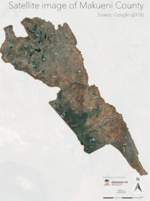
Satellite image of Makueni country. Google 2018
To engage with stakeholders and as an initial step in the development of the hub, representatives from the county government, ICRAF, International Center for Tropical Agriculture (CIAT), the private sector and non-governmental organizations participated in a workshop in Makueni in August 2019.
The Makueni County Government was represented by three County Executive Committee (CEC) members and three chief officers, including Lawrence Nzung’a, CEC Department of Agriculture, Irrigation, Livestock and Fisheries and Julius Kaloi, CEC Department of Lands, Mining, Housing, Physical Planning and Urban Development.
“[The Resource Hub] will help us to see what has been happening, show trends, be driven by credible data, support prioritization and help us in making the right and sustainable decision,” said Philip Wambua Ndambuki, CEC for Gender, Children, Culture and Social Services.
It was designed using the Stakeholder Approach to Risk Informed and Evidence-based Decision-making (SHARED) methodology developed by ICRAF to ensure a tailored stakeholder engagement process centered around the use of evidence in decision making.
Representatives of multiple sectors within the county were engaged, along with partner groups, to address the root causes of land degradation and encourage an exchange of knowledge and collective planning.
They learned about perceptions of degradation, challenges to addressing it and its underlying causes. A key aspect of the exercise was to understand more about Indigenous knowledge and local perspectives.
The county recommended the development of a database of existing activities within Makueni to identify gaps and needs for the county, mobilize partners and make accessible the tools available for prioritizing and implementing future investments.
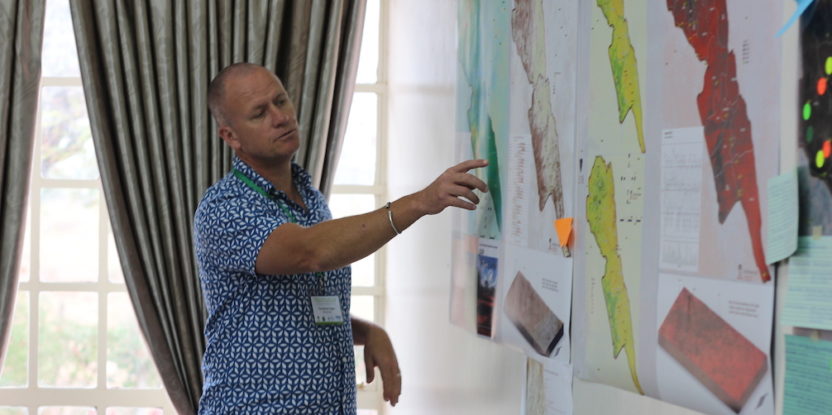
Another key activity in the workshop hosted in Makueni County was to use a “data wall” to allow participants to interact with existing datasets, including maps.
ICRAF presented results from monitoring restoration activities in Makueni over the past four years through the Dryland Restoration Project funded by the International Fund for Agricultural Development (IFAD) and the European Union.

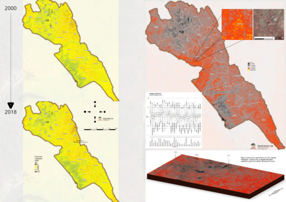
Makueni vegetation and erosion map.
Additionally, Tor-Gunnar Vågen, head of the ICRAF GeoScience Laboratory, presented maps demonstrating soil and tree cover characteristics for Makueni. The maps can be used to prioritize interventions as well as to track changes over time, including for assessing the impact of land management practices on key indicators.
The next steps will include pulling the data together from Makueni County and partners to populate the Resource Hub. The core dashboard team meets regularly to update on progress and discuss visualization preferences and new datasets shared.
The Hub will become an integral tool for data management, evidence-based planning, monitoring and learning in the county.
The Resource Hub is funded in part by CGIAR WLE and supported by projects funded by IFAD/EC and the CGIAR Research Programme on Forests, Trees and Agroforestry.
We want you to share Forests News content, which is licensed under Creative Commons Attribution-NonCommercial-ShareAlike 4.0 International (CC BY-NC-SA 4.0). This means you are free to redistribute our material for non-commercial purposes. All we ask is that you give Forests News appropriate credit and link to the original Forests News content, indicate if changes were made, and distribute your contributions under the same Creative Commons license. You must notify Forests News if you repost, reprint or reuse our materials by contacting forestsnews@cifor-icraf.org.
Further reading
Datasets
Magaju C, Winowiecki LA, Nyaga J, Mumani I, Carsan S, Muriuki J, Muthuri S, Mutua F, Mbuvi C, Maithya S, Mwende M, Muendo S, Sinclair F, Vagen T-G. 2019. Tree Planting Data 2017 – Kenya. https://hdl.handle.net/20.500.11766.1/FK2/UUSV0P, MELDATA, V1
Winowiecki LA, Magaju C, Nyaga J, Mumani I, Crossland M, Muthuri S, Mutua F, Mbuvi C, Maithya S, Mwende M, Muendo S, Sinclair F. 2019. Farmer Profiling Data – Kenya. https://hdl.handle.net/20.500.11766.1/FK2/E4MRCZ, MELDATA, V1
Winowiecki LA, Magaju C, Nyaga J, Mumani I, Wafula L, Crossland M, Muthuri S, Mutua F, Mbuvi C, Maithya S, Mwende M, Muendo S, Sinclair F. 2019. Farmer Profiling Data – Kenya. https://hdl.handle.net/20.500.11766.1/FK2/E4MRCZ, MELDATA, V1